
|
Brad Templeton's Panoramic Photography |
| High Resolution Stitched Panoramic Photos |
| Brad Templeton Home "Brad Ideas" Blog Panoramic Photo Home Photo Home About Panoramas Buying Lenses |
| "Higest-Res" Arizona San Francisco Bay Area Death Valley California Oregon Montana Wyoming Northwest Utah U.S East |
| "Best Panoramas" Europe Russia Sweden Swiss France Balkans Norway Finland Alps Italy Argentina |
| "Newest" Alberta B.C. Ontario Israel Mideast Australia Asia China Japan Africa |
| Burning Man Panoramas: 98-99 2000 '01 '02 '03 '04 '05 '06 '07 '08 '09 '10 '11 '13 16-19 Sampler Giant-BRC |
| Recommended: Use Full Screen button when viewing |
The panoramas for the city of San Francisco itself are on the San Francisco page.
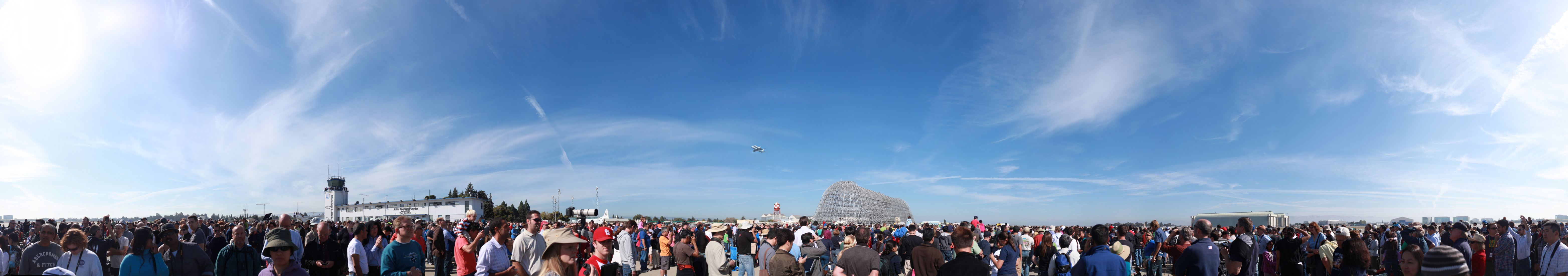
| shuttle1.jpg (6255 x 1100 - 520K) or VR/Zoom! | 360° x 63° (Set) Full size is 66517 x 11697 (778 Megapix) (7' 4" x 16" at 754PPI) |
|
| |
| Space Shuttle flies on top of 747 over crowd at Moffett | |
The space shuttle Endeavour flies its final flight over Moffett Field as a large crowed assembles on the airfield to bid it goodbye. Necessity required that the crowd be shot first, before the shuttle arrived, and it surprised us by coming from behind Hanagar One (the skeleton) so the crowd is looking down the runway, expecting it to come on that path.
| svchopper.jpg (7153 x 1100 - 1459K) or VR/Zoom! | 360° x 70° (Set) Full size is 11628 x 2277 (26 Megapix) (5' 5" x 13" at 180PPI) |
 | |
| Helicopter over Silicon Valley, 2010 | |
This panoarama of Silicon Valley was shot in 2002 from a helicopter 1500 feet over soutwest Sunnyvale, and shows a 360 degree view. Still some flaws since chopper panoramics are new and difficult. This is long before Apple Park or other recent landmarks.
 | silval01-mod.jpg (L) Full size is 5334 x 3556 (19 Megapix) | ||
| San Jose and Stevens Creek | |||
Not a panorama, but a shot taken during my efforts to get a good Silicon Valley panorama. This shot however has been enhanced to remove the haze, to show what San Jose would look like if there were no pollution. Next winter, I will shoot a decent panorama like this.
| ummunhum-long.jpg (15658 x 1100 - 3843K) or VR/Zoom! | 180° x 12° (Set) Full size is 106500 x 7481 (797 Megapix) (18' 5" x 16" at 482PPI) |
 | |
| Silicon valley from Mt. Ummunhum | |
| windy70.jpg (9772 x 1100 - 2436K) or VR/Zoom! | 160° x 18° (Set) Full size is 26785 x 3015 (81 Megapix) (11' 6" x 15" at 194PPI) |
 | |
| SF Peninsula from Windy Hill | |
The whole Bay Area, with SF on the left, SJ on the right, from Windy Hill overlooking Stanford and Palo Algo
| mtbello50.jpg (5409 x 700 - 378K) (Lost) | (L) Full size is 16089 x 2082 (33 Megapix) (7' 5" x 12" at 180PPI) |
 | |
| Whole Bay Area from Montebello ridge | |
The whole Bay Area, from SF to Gilroy, from the top of Montebello Ridge.
| sv-south.jpg (8343 x 1100 - 1361K) or VR/Zoom! | 200° x 26° (Set) Full size is 38847 x 5122 (199 Megapix) (9' 10" x 16" at 330PPI) |
 | |
| San Jose from the eastern Foothills | |
This giant image was taken with Fuji Velvia from the top of Quimby Road at noon during the winter green season. It shows all of Silicon Valley. You can even see San Francisco, over 50 miles away, through the haze on the far right of the picture.
| sjhilton.jpg (8421 x 1100 - 1704K) or VR/Zoom! | 325° x 42° (IVR) Full size is 15832 x 2068 (33 Megapix) (7' 4" x 11" at 180PPI) |
 | |
| San Jose from roof of Hilton | |
All of downtown San Jose, from the top of the Hilton. This view doesn't really exist, as I had to move around the hotel and play some tricks.
| ames-eclipse.jpg (3103 x 700 - 155K) (Lost) | (L) Full size is 13525 x 3051 (41 Megapix) (5' 9" x 16" at 196PPI) |
 | |
| Moffett Field during Eclipse of Moon | |
This panorama shows the dirigible hangars and wind tunnel at Nasa-Ames / Moffet Field during the May 15, 2003 total eclipse of the moon. Moon is at left, above Hangars 2 and 3.
| sj-winter-storm.jpg (5243 x 600 - 194K) (Lost) | (L) Full size is 18726 x 2143 (40 Megapix) (8' 8" x 12" at 180PPI) |
 | |
| San Jose in Winter Storm | |
San Jose in a rare winter storm, with snow on the hills, and rain over the airport area.